John Vonderlin: Hi June. Here’s the answers for your photo. The experts have done it again. That was fun. Enjoy. John
————-
Hi John [Schmale],
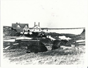
June sent me the photo of Montara Creek and the strange rail-like device suspended over it a while ago. Mr. Perkovic sent me an email after I sent him the picture and this is my reply. I’ll forward that to you next. Any thoughts about whether this could be OSRR or something else. Do you have a good picture of their sidehill trestles in this area? I’ve been unable to find a good picture of one. As you can see from my reply to Paul, I’m dubious this is the OSR rails, but rather unsure. I wish the picture was better resolution. Enjoy. John [Vonderlin]
———————
Hi, John,
Thanks for forwarding that photo.
I can only offer the following hypothesis: The view appears to be looking towards the west, with the main building of the lighthouse complex on the left, the foghorn building (with twin exhaust vents) in the center, and the smaller building that is now part of the hostel on the right. There appear also to be several smaller buildings on the west side of the strange rails. The viewing location seems to be at about the same level as the gound floor of the buildings. And the “strange rails” appear to be the Ocean Shore Railroad, suspended.
Highway 1 currently crosses Montara Creek with a culvert providing passage for the creek, and a significant amount of fill forming the base for the roadway. I suspect that the Ocean Shore Railroad might have also had an embankment or fill in the same location (rather than a trestle to span the creek), but with inadequate drainage capacity, and that a major flood washed out the fill. There are no signs of any trestle members still attached to the crossties, whereas fill and normal gravel bedding would simply wash out.
Maybe there is something in one of the Ocean Shore Railroad histories. I’ll keep this in mind as I wander around the area, and see if I can find an appropriate location for a photo.
Paul Perkovic
——————
Hi Paul,
Thanks for your thoughts. And the efforts to take the pictures you sent. I’m going to send the original picture on to a couple of OSRR experts who often can help us solve questions. I’ve attached several ScreenShots of photos from Californiacoastline.org. from the 70s and 80s of the creek area. I’ve also attached a trestle index from Jack Wagner’s book, “The Last Whistle.” It shows no trestle from McNee to Pillarcitos. None of the stated lengths of the trestles without a set location are even close to the apparent length of the suspended stretch that is visible in the photo. There are 70 plus ties visible or about 100 feet. Given the absence of any close slope to where the rails disappear to left and right on the photo I’m thinking a 150 foot minimum. That’s if we were looking at railroad tie spacing of about 18 inches. Many of them aren’t well-spaced or as parallel to each other as they should be, even after a flood that had undermined their footing. In some places there are sections with a number of widely spaced ties in a row, which is hard to do without bunching elsewhere, which I don’t see. Other places the ties have alternate slants, which would seem to be hard to duplicate without them being loose from the spikes. Then there is the weight of that much railing…how is it strung so straight across the gap, with so little bowing to gravity? How does unwelded rail stay together with that pull on it?
The following excerpt from an old newspaper article about the Spring Valley Water Works hints at a possible pipe or flume support spanning a gap that sounds like this same circumstance. Could that “rail” assemblage have supported an iron pipe across the gap before the flood? Or was one to be installed but the rain delayed it? Did Montara ever have a waterline running down from the north along the coast road? Either a flume or iron pipe?
. Thanks for your help in solving this puzzle. I’ll notify you of developments. Enjoy. John
“until it reaches what is known as the San Andres Valley, which it crosses by a heavy iron pipe, a distance of about fifteen hundred feet, and thence the level is undisturbed into town. A similar pipe, or perhaps a wire suspension bridge will be needed at the gap next the Abbey, known as the “Portasuelo,” for the flume to pass over.”
——————-
Hi John et al,
The photo in Wagner’s book shows the the Ocean Shore RR tracks at Montara following a flood caused by a very intense storm. The storm water backed up behind the railroad fill to a depth of over 40 feet. On January 13, 1916 the clogged culvert passing under the railroad fill was blown up using dynamite. The resulting torrent of water tore away the railroad embankment as well of that of the highway. The photo was taken after the fact showing the tracks suspended in air. The tracks are bolted together through “fish plates.” A trestle was built to replace the fill. Many slides up and down the line closed the Ocean Shore for over a month. I hope this helps
John Schmale
The local water company installed a dam in the creek just up stream from the Ocean Shore Railroad tracks
The local water company installed a dam in the creek just up stream from the Ocean Shore Railroad tracks
————————-
Hi, John. Thanks for your email and attachments re above. Info I find on the Internet is that on mainline track (in 1988) ties were spaced at 19.5″ centers and somewhat more on sidings, yard tracks, etc. What standards applied in the early 1900s I don’t know, and whether the OS followed them with any precision I’d say is doubtful.
The reason the washed out rails hold together is that fish plates (metal bars with bolts) hold the rail ends together as intact units– see the picture under fish plate in Wikipedia. I sometime ago found a story and picture of the (I believe) same washed out trestle and the Montara flood (dumb me, don’t think I kept it; but will recheck my OS Favorites and if find will forward. I believe this was the trestle at McNee; extremely unlikely this is the southernmost step or sidehill trestle, which type had one side of the track supported by the hill or mountain and the other side by pilings/trestle-work, and it is not the Pilarcitos trestle at Half Moon Bay. Since the Trestles page in Wagner’s OS book stems from the 1911 Bondholders Report of the Ocean Shore Railway and if the flood was prior to that date (was it 1909?) then the replacement trestle may have been somewhat shorter or longer depending on embankments at the ends. Incidentally, when I replied on a recent email to John Schmale and cc’d to you and June, I wished John and his wife a Happy Thanksgiving, but neglected to include you and June. It’s not too late, and so Happy Thanksgiving to you John and to your mother, and to June. Angelo
